 Ben Nevis probably the most well known mountain in the UK, due to its lofty position 4409 feet, the highest point in Britain. I've walked the Ben twice before both times with others which prevented me from going the route I would like. The "Tourist route" is a long trudge and not a route I would recommend, other than to descend unless your aim is just to say you've done it and tick it off.
The route that has kept me awake at night dreaming of finally walking, is the Carn Mor Dearg Arete route. This was finally the day I could put the dream to bed once and for all, hopefully it would be third time lucky. I had walked the Ring of Steall the day before and thought I may be aching, especially after sleeping on the back seat of my car in a car park at Fort William. Thankfully I awoke early feeling fresh with the absence of any achy muscles. The weather was looking like it may be kind to me, generally blue skies with only the highest mountains clinging to their cloud blankets (Ben Nevis then).
I have become an expert at finding parking places that are free, so rather than parking in the main visitor centre car park I parked in a layby where the sign informs you that the car park and visitor centre is either 200 or 400 metres (can't remember which now). I wandered along the tarmac path towards the visitor centre, remembering walking the opposite direction a few months earlier at the end of my WHW walk. The car park was far quieter than I expected, it was a weekday I guess. I had a glance at the parking meter so I could revel in my delight at saving money and was surprised to see it was only £3.50, in some ways I felt slightly guilty.
Even though it was quite early there was already a steady stream of people snaking up the path ahead. I was in no rush today and intended to enjoy the day as much as possible, although I still found myself passing lots of people or attempting to, many were walking 2 or 3 abreast and were oblivious to my "Excuse me please" polite requests to pass. Several people passed me too, who were rushing to get to the top, most I met again before the lochan pausing to get their breath back. You see some strange sights on Ben Nevis, people who clearly don't realise it will be quite chilly at the top compared to the car park at the bottom.
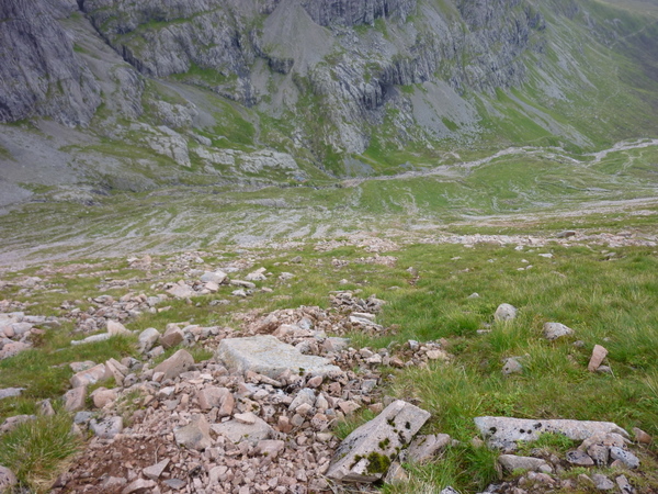
 By the time I reached the lochan which is thought of as the halfway point for the tourist route I was pleased in the knowledge that I would shortly be splitting off the main route. The cloud was still cloaking the Ben from about 3000 feet. As I walked along the flat stretch towards my route turnoff a helicopter approached from the North and landed next to several containers of the kind used to transport goods on ships, there was a hive of activity around the area. I am fairly certain these were there almost 3 years ago. It was with some relief that I left the main path and followed a smaller track away from the rivers of people.
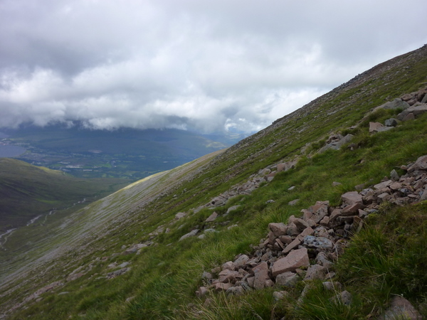
 Walking around the other side of the Ben the path becomes rockier and not so well maintained, but still a very clear path. I could see the start of the long ridge that would lead to Carn Mor Dearg, which was currently hidden by the massive bulk of Ben Nevis. The very clear path from the North of Fort William also came into view. This could be a good alternative way to ascend Ben Nevis, I'd certainly look at it for the future.
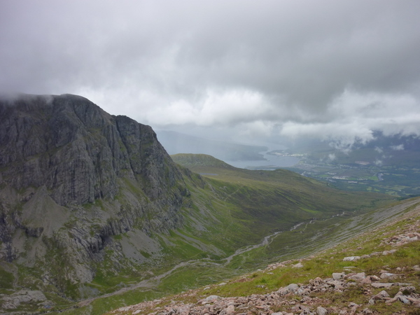
 The further I rounded the corner, the more spectacular the view became. The long sloping ridge up to Carn Dearg Meadhonach and then Carn Mor Dearg is a long sloping quite steep route, I'd been considering walking up this way but decided to continue to the actual CIC Hut. The route to the climbing hut and then heading straight up to the side is the one most people choose from this side. The further I walked the more awe struck I became, its hard to believe this is the same mountain I'd trudged up and down having felt happy for making it but underwhelmed at the route. I found myself routed to the spot, staring up at over hanging rock and said out loud "wow". I wonder how many others have stood and said the same on seeing the same sight for the first time.
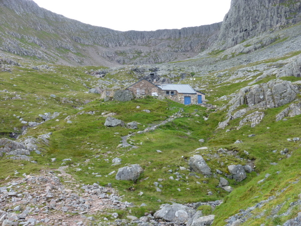 I was beginning to think the climbing hut was a mirage, it wasn't getting any closer. Eventually I stood just below the hut and drank some freezing cold water from the stream. While I gazed, feeling almost cocooned by the rock around me a couple walked past me having followed the path from Fort William. They continued on to the hut itself which I believe is locked and you need a key for, I think they found this out. I looked to my left and though "bugger" that's quite steep. There was no obvious path heading up the side, there did appear to be lots of what looked like little paths higher up.
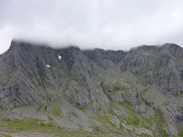 I had a quick check of the route and decided to head more or less straight up aiming for somewhere between Carn Dearg Meadhonach and Carn Mor Dearg. There were lots of what looked like paths, I'd start to follow one and it would disappear. I gave up trying to follow these and forged my own path, the progress felt slow. I paused and looked back, realising the hut was now but a dot in the valley below. Ben Nevis looked immense, rocks jutting out from every angle. I watched as a pair of climbers headed up to the base of one of the gulleys, higher above them there was still a small patch of snow. The Arete could be clearly seen now, I smiled one of my crazy smiles, turned and sprung up the hill like a man possesed.
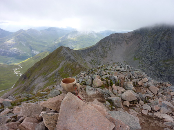
 As I was leaping up the hill 2 deer crossed my path, I was surprised to see them up here. The slope gradually became less severe and I could see the summit of Carn Dearg Meadhonach and Carn Mor Dearg. I decided to head for the former it would be rude not too while I was up here. The obligitory Kuksa summit picture was taken and I paused to take in the magnificent views. Every mountain was clear of cloud, except for one, no prizes for guessing which.
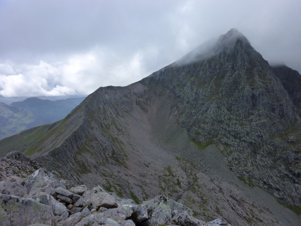
 I couldn't wait to get to the arete, I'd waited over 4 years and didn't wan't to postpone any longer. I headed along the ridge and up to Carn Mor Dearg, only pausing to speak to a guy who had no intention of walking the Ben as he'd done it before. He'd spent the previous day walking the grey corries. There was no way I would be able to stop myself walking along the arete if I was as close as he was to the start. Once at the top of my first Munro of the day, again Kuksa summit pictures were taken. My jaw dropped as I looked along the length of the arete, while I was picking it up from the floor, The Ben decided to give me the briefest glimpse of its summit. My draw promptly fell to the ground again. I felt so happy to be where I was looking at the view and about to walk something that was special (at least to me).
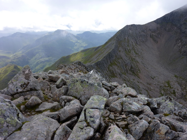 I descended down keeping to the highest point of the ridge as much as I could, reaching the arete proper, which isn't quite as difficult as I had imagined. I decided I was going to walk it by staying as high as possible, not taking the paths to the side and experiencing the route how I felt it should be done. Luckily the rocks were dry or this could be of been potentially dangerous, as much as possible I stuck to the highest points, often with my feet balancing precariously on rock an inch wide. I carried my pacer poles in front of me, which reminded me of someone walking a tight rope with a pole. Beneath me there were crampon marks over most of the rocks, my thoughts drifted to doing this in the winter.
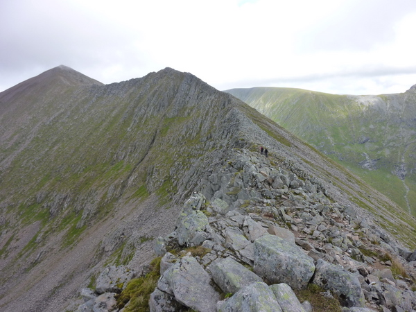 To be honest the arete was far easier than I was expecting, I was making it slightly harder than it need be, but having fun. The drop down to my right towards the climbing hut is actually quite low at times. While I was sticking to my high route, 2 younger lads headed towards me, the second of which was crossing most of it on his bum. When they drew closer, the look of sheer terror was evident on the second lads face. Surely it couldn't of been the route, they were taking an easier line than mine. Maybe it was the demented smile on my face that had him clinging to the rock as if he had just seen the grim reaper.
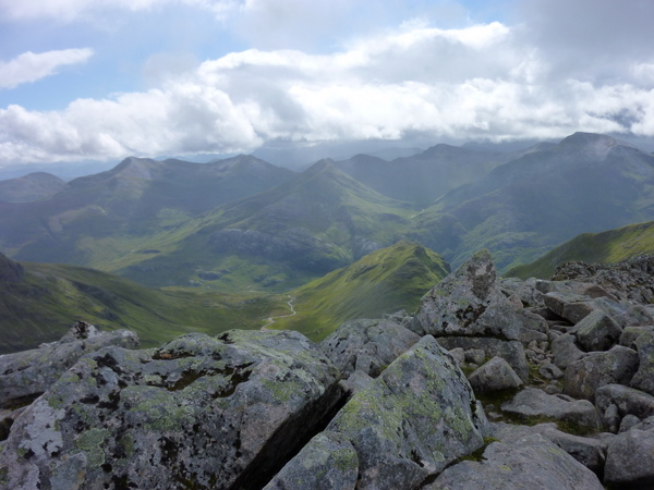
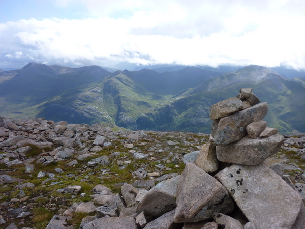 The airy arete was over far too soon, I did contemplate walking walking back along again but decided I still had some steep ascent to the summit of the Ben. The views across to the Ring of Steall route I walked the day before were simply superb, the sight of the Mamores had me making mental notes to add them to my next TGO Challenge crossing. Peering down from the abseil posts which looked quite tame today, I could see people below. Onwards and upwards...
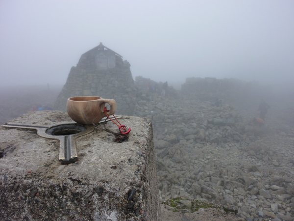
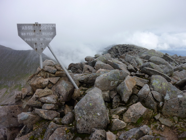 Almost immediately after leaving the abseil post sign I walked into a wall of cloud. The route kept disappearing or rather I kept loosing it in the low visibility. This reminded me of the first time I was on Ben Nevis and you can feel slightly disorientated. Eventually the route flattened and I knew it wasn't far to the summit, I could now see several cairns which turned out were marking the edge of the drop, luckily I checked the direction I should be heading and didn't blindly head towards the cairns. This felt a bit strange, the cairns which remain on the tourist route up are the ones you should follow, this side they were at the edge of a rather large drop. Anyway a few minutes later and groups of people could be heard then seen. The summit of Britain was once again reached, again Kuksa pictures at the top were taken and while eating my lunch I realised the actual highest point would be the roof of the shelter. The thought did cross my mind to put the Kuksa on the roof, but decided against it.
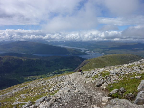
 I hung around for about 15 minutes in case the cloud lifted, it didn't so off I set for the descent along the easy path. The cairns having been cleared the previous Sunday by the John Muir Trust were far more useful than the last time I walked the route. Previously there were cairns everywhere which could be confusing and dangerous if you followed them without checking a map. I had no need of either today there was a line of people heading towards me and the cloud was thinning. The descent I covered very quickly at a fast walking pace, aided by Pacer Poles. Two young lads ran past me, but this turned into leap frog with them running then walking whereupon I would catch them up. A few times near the bottom of the track I found myself almost jogging with my target firmly aimed at the Ben Nevis Inn. The lower I got the hotter it became and when I eventually reached the Inn, the pint was well deserved sitting in the sun looking at the view around me.
 If you are intending to walk Ben Nevis, seriously consider the sublime CMD Arete route but only if you are a relatively fit walker. You can find the route here on Walk Highlands.
Comments